Here you can find a wide range of self-guided walks in Chesterfield and the surrounding area. Just follow the links below…
LATEST – There’s a wonderful Winter Windows trail all around the town centre. Click here for the route, which runs until Monday 5th January 2026.
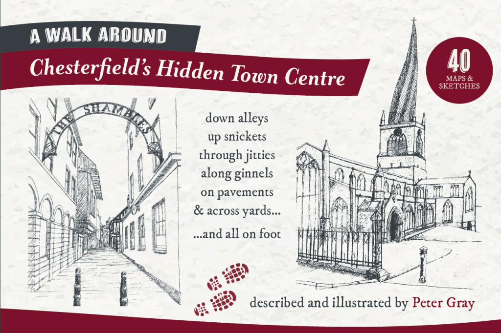
ON SALE NOW… “A Walk Around Chesterfield’s Hidden Town Centre” by Peter Gray
Copies available in town from Steph’s Sustainable Stuff, Brockwell Books, The Crooked Spire Gift Shop, Huckleberry Willow, Delightful Decor, Waterstones and Bannister Publications (online).
A three-mile walk around Chesterfield’s hidden (often in plain sight) town centre – never re-tracing your steps and always within a third of a mile of the Crooked Spire.
_____________________________________________________________________________________________________
2025 Chesterfield Area Walking Festival From Saturday 10th to Sunday 18th May
More walks in Chesterfield…
“Explore Chesterfield” and “Chesterfield’s Black and White Buildings”. Two walks in the town centre produced by Chesterfield & District Local History Society.
Historic Town Centre Walking Trail. This route, by the Borough Council, visits a number of the town’s more famous locations.
Chesterfield’s Art Trail. This trail covers the town centre and a number of other locations in and around the town – as far as Staveley.
Chesterfield 750 medieval walk. Produced in 2016 as part of the commemorations to mark the 750th Anniversary of the Battle of Chesterfield.
Rivers of Life. A 1.2 mile walk along the River Hipper to Spital Cemetery created by the Don Catchment Rivers Trust and the Friends of Spital Cemetery.
Holmebrook Valley Trail. Follow the Holme Brook form the town centre out to Holmebrook Valley Park. 2 miles. Devised by Don Catchment Rivers Trust.
The Crooked Spire Tower Tour. Not really a walk, but the views from the top of the tower are great.
The Ancient Chapel of Newbold. Issue 140, page 18 of the local magazine S40 has an interesting reprint of a 1915 exploration of Newbold.
Historical Tales and Traditional Ales. A route around the town centre pubs. Pick up your copy (suggested donation £1) at any of the dozen pubs in the town.
Spital Cemetery. Not a self-guided walk, but the Friends of the Spital Cemetery do a walk there once a month. The cemetery is just to the west of the town centre. S41ODZ WhatThreeWords: moss.flag.brick
and around Chesterfield…
Chesterfield Borough Council’s website has a good selection of walks and areas in which to walk. Varying lengths and terrains.
The Drone Valley Way. A 7.5 mile walk between Chesterfield and Dronfield. Devised by Dronfield Footpaths and Bridleways Society.
Countryside south of Chesterfield. A 4.5 mile circular walk in the countryside just south of Chesterfield.
The Chesterfield Canal Trust has a variety of walks based on the Chesterfield Canal
The Chesterfield Round Walk – 34 miles… around Chesterfield.
If you fancy walking (or wheeling) from Chesterfield to a nearby settlement (Staveley, Bolsover, North Wingfield, Bakewell, Dronfield etc.) all the best low/no traffic routes are here… Slow Ways.
and… because it’s there…
Contact us
We’d love to hear from you! Drop us a line below and we’ll do our best to get back to you as soon as possible.
Your message has been sent

